marți, 24 ianuarie 2017

Maroc 19-30.08.2016 - ziua a patra/day 4 23.08.2016

Ca și ieri, trezirea este tot la 6.00 și puțin după 6.30 suntem în fața cabanei. Mai sunt câțiva gata de drum, dar spre Toubkal, nu spre Ouanoukrim în sus pe valea Asif n'Ouagnunee! Pornim la 6.49 în sus pe vale, cam pe aceeași lumină ca și ieri.

As yesterday, we wake up at 6.00 and a few minutes after 6.30 we are in front of the shelter. There are some people ready to go, but to Toubkal, not to Ouanoukrim up on the valley Asif n'Ouagnunee! The start is at 6.49, on a similar light as yesterday.
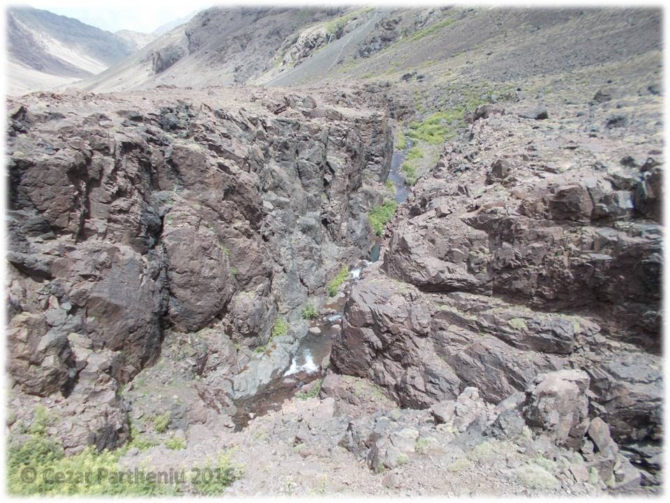
Poteca urcă tot în sus chiar de la cabană, trecem pe lângă zona de captare a apei și facem stânga pentru a ocoli în urcare o zonă stâncoasă. Ajungem lejer deasupra ei și cam în 20 de minute suntem la primul ”hop” și spectacol: un canion se adâncește în vale vreo 15 metri sub noi și prin fundul lui curge o apă cu cascade! În dreapta se văd crestele ascuțite care încep să se înroșească. Ce seamănă cu Dolomiții! Poteca tot urcă pe mijlocul văii și o urmăm absorbiți de peisaj. Trecem cumva de intersecția cu poteca ce urcă la stânga spre șaua Tizi Ouanoums și apoi pe creasta lui Toubkal West. Revenim la poteca noastră, principal și căutăm drumul prin primul canion cu verdeață (țepoasă, ați ghicit!)

The path goes up directly from the shelter, we pass the area for capturing water and turn left to avoid a rocky area. We reach her upper part of the rocky area very easy and in about 20 minutes we have the first ”test” and show: a canyon in the valley deep about 15 meters below us with water and waterfalls on the main line! On the right the ridges start to color in red. They look a lot like Dolomites! The path goes along the valley and we follow her fascinated by the landscape. In some way we miss the cross where a path goes on left to Tizi Ouanoums saddle and then to the ridge of Toubkal West. We come back to our main path and look for the way in the first green canyon (thorny, you guessed!)


Găsim o potecă ce urcă pe malul stâng al canionului (malul drept e vertical, în sensul de urcare) și pe un grohotiș revenim iar la firul văii. Momâile ne conduc pe partea stângă (geografic, dreapta cum urcăm noi!) și încep câteva serpentine la dreapta. Fiecare merge în ritmul lui și ne regrupăm deasupra serpentinelor și a altui canion uscat. 

We find a path that goes on the left side of the canyon (defilee, the right side is vertical, the way up) and on a scree we go back to the main valley line. The small rock pyramids lead us on the left side (geographically, right as we climb!) and we have some bends on the right. Each follows his rythm and we regroup above the bends and another dry canyon.


Soarele acoperă din ce mai mult creasta zimțată în dreapta căreia identificăm valea pe care se poate coborî iarna de pe Ras. Ultima pantă ne urcă în șaua Tizi n Ouagane la 3730 metri altitudine. 

The sun covers the jagged ridge on the right and we identify the valley that one can use to go down in winter from Ras. The last slope leads us to Tizi n Ouagane at 3730 meters altitude.


Spectactolul este magnific aici: în spate și în față se alungesc două văi sub formă de canion larg. Ce seamănă cu fiordurile norvegiene (îmi aduc aminte de fiordul de sub Reinaknuten, detalii aici). Câteva minute de odihnă și mergem mai departe. Mai ales că încă șaua este în umbră și abia așteptăm soarele. Ăsta e motivul pentru care îl aștept pe Ștefan puțin mai sus la soare. 

The show is magnificent: in front and rear you can see two long valleys in a large canyon shape. They look a lot like norwegian fjords (I remember about the fjord under Reinaknuten, details here). A few minutes to rest and continue further. Because the saddle is in shadow and we wait for the sun. This is the reason for waiting Ștefan upper in the sun.


Fiindcă am puțin de așteptat, cercetez zona pentru continuarea traseului. Spre sud pare să fie o șa și apoi o mare căldare. Merg până la buza ei și văd niște vâlcele înclinate care urcă spre vârf. Pentru a ajunge la ele ar trebui să coborâm cel puțin vreo 200 de metri și apoi să urcăm prin ele. Cine știe cum sunt... Revin pe platoul însorit și în dreapta jandarmilor (turnuri de stâncă) văd o mică șa și o momâie. Pe aici este! Mă întorc bucuros de descoperire la Ștefan care ajunsese și face o pauză scurtă. Când suntem gata urcăm pe la momâie, apoi pe o potecă clară pe sub alți jandarmi, trecem de o șa și începe urcarea pe creasta ascuțită. Este cățărătură elementară și îmi pare chiar frumoasă! Urcăm până la o mică platformă, cercetez vârful din față și văd că dă într-o șa adâncă. Înapoi și pe sub vârf pe o curbă de nivel la altă momâie! Ajungem pe curbă de nivel ușor la stânga în șa, continuăm vreo 50 de metri în față și apoi cotim la stânga pe un șir de plăci lucioase pe o curbă de nivel ce ne urcă tot în sus pe creastă. Îi urmează o trecere la dreapta printr-un mic canion, apoi la stânga pe canion și ajungem la zona cu grohotiș de sub cele două vârfuri. De aici panta se îndulcește la 30 de grade spre vârful Ras (cam 3900 de metri altitudine). 

Having some time to wait, I investigate the area for continuing the path. In the south I find a saddle and a big bowl. I go to its limit and see some steep scree valleys going up to the top. For them we have to go down about 200 meters and then up on them. Who knows how they are... I come back on the sunny plateau and see a rock pyramid in a saddle on the right of the jandarms (rock towers). This is the way! I turn back to Ștefan happy for the discovery and he had just came and has a short break. When we are ready, we go up to the pyramid, then on a clear path under the jandarms, pass a saddle and then up on the sharp ridge. It is elementary climbing and it looks really nice to me! We go up to a little platform, I investigate the summit in front of me and it goes to a deep saddle. I turn back and on a levelled path we reach another pyramid and to another saddle. We continue about 50 meters in front and turn left on a line of flat shinny rock plates going up on the ridge. There is a path through a small canyon to right and then to left and we reach the scree area under the two summits. The slope goes to 30 degrees to Ras summit (about 3900 meters). 


Poteca ne conduce în sus pe marginea pantei cu grohotiș, sunt destule serpentine și dintr-una din ele ieșim un pic la dreapta spre un ”Revolver” (ceva mai mare ca cel din Făgărași) țintit spre Ras. Putem vedea tot abruptul nordic cu șaua adâncă ce duce spre Akioud și apoi continuarea crestei amintite de câteva ori. Revenim la poteca de urcare și pe ea ajungem la vârful intermediar din zona de vârf (circa 4060 metri). Câteva poze, identificăm cele două vârfuri mari și pornim spre Ras după ce ne lăsăm bețele jos (Ștefan aici, eu în șaua următoare). 

The path takes us up on the limit of the scree slope, there are a lot of bends and in one of them we exit to right to a ”Gun”/”Revolver” (bigger that the one in Făgărași) with the pipe headed to Ras. We can see the whole nordic wall with the deep saddle going to Akioud and the ridge I told you about for a few times. We turn back to the climbing path and reach the intermediate summit in summit area (about 4060m). A few pictures, we identify the two big summits and head to Ras after letting the poles down (Ștefan here, me in the next saddle).


Merg în față să descopăr poteca și pașii, confirm fiecare treaptă și după o cățărătură elementară suntem chiar în zona vârfului. Ras, 4083 metri! Ne felicităm. E un loc și peisaj fantastic. Doar munți în toate direcțiile până la ceața care coboară spre podișul vest-marocan. Spre sud-sud-est doar intuim direcția deșertului... Facem mici filmulețe, multe poze cu munții și câteva cu noi cu steagul național, ne odihnim câteva minute și înapoi la bețe și mai departe.

I go ahead to investigate the path and each step, I confirm every step and after an elementary scrambling we reach the summit area. Ras, 4083 meters! We congratulate each other. It is a fantastic place and landscape. Mountains all around to the fog that goes down to west-morroccan high plane. To SSE we just suppose the direction of the dessert... We make small movies, a lot of pictures with the mountains and a few with our national flag, we rest for a few minutes and then back to the poles and further.


Ștefan ocolește vârful intermediar să-și recupereze bețele, eu le iau din șaua dintre cele două vârfuri și merg pe o curbă de nivel spre marea șa spre Timesguida. Poteca vizibilă nu mă lasă prin hăuri și mă urcă în creastă unde mă întâlnesc cu Ștefan. Era logic să ne întâlnim! Coborâm în șa și urmăm serpentinele care ne urcă pe o pantă lejeră cu grohotiș spre platoul vârfului. Tot așa regrupăm înainte de zona vârfului și ajungem amândoi la marea momâie ridicată la 4088 metri pe Timesguida. În jurul ei sunt tot felul de momâi sub aspectul unui ceas solar. Facem pozele de vârf cu Ras, Toubkal și creasta celor trei patrumiari în fundal, ne așezăm să mâncăm ceva și avem surpriza ca dinspre valea sudică să apară câteva capre ”alpiniste”. Chiar și aici! Nu se apropie de noi, stau pe la 60-70 de metri distanță și găsesc ce să mănânce!

Ștefan goes after the intermediate summit to take the poles, I take mines from the saddle between the two summits and go on a level path to the great saddle to Timesguida. The visible path guides me to the ridge where I meet Ștefan. Logically! We go down in the saddle and follow the bends on a light scree slope to the summit plateau. We regroup in the same way before the summit and reach the big pyramid at 4088 meters on Timesguida. There are a lot of small pyramids in a form of a solar clock. We make the summit pictures with Toubkal, Ras and the 4000's ridge in the background, sit to eat something and have the surprise to see some ”climbing” goats. Even here! They stay at 60-70 meters from us and find something to eat!


Din vârf vedem o potecă ce coboară pe sub Ras spre locul unde intrăm spre creasta de descățărare. E un grohotiș lejer până acolo și apoi urmează drumul cunoscut până în Tizi n Ouagane. Cu coborâri frumoase și artistice :D!

From the summit we see a path going down under Ras to the place of entering the down-scrambling ridge. It is a fine scree to that place and then the known way to Tizi n Ouagane. With beautiful and artistic downs :D!


Văzusem de pe vârf doi oameni care urcau pe valea sudică spre șa. Aici ne întâlnim cu ei și vedem că sunt doi ciobani care urcaseră să își recupereze caprele rătăcite! Ce simplu! Ne salutăm și la vale spre cabană!

On the summit we saw two men going up on the southern valley to the saddle. We meet them here and see that they are two shepperds serching for their goats! How simple! We salute and go down on the valley to the shelter!
Cu excepția potecii normale care ocolește canionul în care am intrat la urcat, drumul este același ca mai devreme. Partea diferită a venit la inspirație pentru a merge pe la un lac/baltă ce se vedea de sus. Este o urmă nămoloasă a ploii de aseară! Încă nu se anunță nimic pe cer, e soare și noi coborâm știind ce repede se schimbă vremea. Și exact așa este. La 14.30 suntem la cabană și începe o răpăială cu grindină care a format cascade de ziceai că rup muntele! Doar așa ca să confirme că natura nu se joacă!

Except the normal path going around the canyon we entered when going up, the path is the same as earlier. The different part came at inspiration to see a small lake seen from the upper slopes. It is a muddy proof of the yesterday rain! There is nothing on the sky, it is sun and we go down knowing how fast the weather changes. And it happens exactly like this. At 14.30 we are at the shelter and a heavy rain with hail starts and make waterfalls that seem to break the mountains! Just to confirm that nature is not for playing!




Acum merităm relaxare, masă, privit la poze și la cei care abia au venit și se pregătesc de urcare ziua următoare... Ne uităm la panoul cu amintiri și ne vine ideea de mai jos. Sunt curios cât va ține și personal nu văd un motiv să dispară :D!

We deserve relaxing, dinner, wathcing at the pictures and the people that just came and get ready to climb the next day... We look at the memories panel and have the idea you see here. I am curious how long it will stay and don"t find a reason to dissapear :D!
Mâine vom coborî și continua spre alt lumi marocane!

Tomorrow we go down and continue to other morroccan worlds!

Maroc 19-30.08.2016 - ziua a treia/day 3 22.08.2016

După cum spuneam ieri, ne-am plănuit o plecare matinală ținând cont de ploaia de după-amiază. Mi-era așa un pic teamă că vom avea zăpadă la mijloc de august după ninsoarea de aseară și totul e uscat. Așa că Muntele ne promite o zi tare faină!

Ne trezim pe la 6.00, mâncăm ceva rapid de dimineață și căutăm să facem cât mai puțin zgomot. E deranjant pentru cei care nu au planuri de vârfuri azi, cei care au ca scop să urce sunt în picioare ca și noi. Cu tot ce trebuie în rucsaci mici de tură, cu bețele în mâini, îmbrăcați adecvat (geacă impermeabilă, căciulă, mănuși, cagulă de rezervă) suntem la 6.40 în fața cabanei, facem câteva poze și pornim la drum. Văzusem un grup care a pornit cu ghid pe poteca ce urcă spre Tizi n Toubkal (șaua Toubkal) aflată între cele două vârfuri de peste 4000 de metri cu denumire asemănătoare. În masivul Toubkal mai este și patrumiarul Imouzzer (4040m) aflat pe creasta nordică a vârfului principal! Mergem după ei până puțin după prima cascadă (studiasem poteca de ieri cu ochii minții și cu descrierea în mână) și vedem că fac prea multe pauze. Trecem în față!

As I said yesterday, we planned a morning start knowing about the afternoon rain. I was afraid that we might have snow in mid-august with the snow from last night and now everything is dry. So the Mountains promises a very good day!

We wake up at 6.00, eat something fast and look for not making so much noise. It is annoying for the ones who plan to stay here or sleep, the ones who climb up are ready like us. With everything packed, with the poles, dressed appropiately (anti-rain coat, winter cap, gloves, hood) we are ready at 6.40 in front of the refuge, make some pictures and start t owalk. We saw a group with a guide walking on the path to Tizi n Toubkal (Toubkal saddle) between the two 4000 summits with similar names. There is another 4000 summit in massive Toubkal (Imouazzer, 4040m) on the north ridge of the main summit! We follow them to the first waterfall (we studied yesterday the path in our mind and with the description on the phone) and see them making a lot of breaks. We go ahead of them!
Întâi urcăm pe dreapta văii și o potecă ne duce în marele grohotiș. E prea alunecos. ”Cezar, nu ai luat-o bine, mergi mai la stânga!” Are dreptate Ștefan, crește panta și grohotișul nu ține. Găsesc o potecă la stânga și ajung pe platforma de sub banda galbenă de piatră. Aici vedem poteca largă și evidentă. Prin semi-întuneric vedem pete albe de zăpadă căzută aseară. Poteca ne duce spre stânga până la capătul benzii și apoi cotește drepta pe un vâlcel pietros. Îl urmăm în sus și ieșim pe plăci mari și înclinate deasupra benzii. Facem puțin dreapta spre centrul văii, apoi la stânga alegem un vâlcel care ne urcă într-o zonă de platou undeva pe la 3450 de metri. De aici poteca urcă foarte clar pe versantul drept aflat sub peretele nordic al vârfului Toubkal West. Undeva deasupra lui e o variantă de potecă spre vârful amintit! În spate se luminează și creasta Akioud (4030m)-Afella (4040m)-Biguinoussene (4007m) se înroșește în culorile răsăritului. În stânga și în dreapta noastră avem (cum ne uităm spre vale) creasta vestică a Toubkal West, respectiv creasta vestică a lui Imouzzer zimțată. Spectacol care poate fi înțeles doar din imagini!

At the beginning we climg up on the right and the path takes us to the big scree. It is too slippery. ”Cezar, it's wrong, go to the left!” Ștefan is right, the slope is bigger and the scree is unstable. I find a path to the left ant reach the platform under the yellow rock band. We found the large obvious path! In semi-darkness we see white snow spots from last evening. The path takes us to left to the end of the band and then turns right to a rocky small valley. We follow it up to some big plate inclined rocks above the band. We turn right to the center of the valley, then choose a small valley that takes us to a plateau around 3450m. Starting from here, the path goes clearly on the right side under the nordic wall of Toubkal West. There is a path above this wall! In our back the ridge Akioud (4030m)-Afella (4040m)-Biguinoussene (4007m) colors to red in the sunrise colors. On the left we have (as we look to the valley) the western ridge of Toubkal West and on the right we have the western jagged ridge of Imouazzer! You understand the show in the following images!


Tot spre est în urcare și sub Toubkal West ajungem în căldarea superioară la 3750 de metri și urcăm poteca mai abruptă în serpentine strânse. Tot cad pietre și pietricele! Depășim ultimul prag și ni se îndulcește panta de sub șaua Tizi n Toubkal. Urcușul direct (sunt multe serpentine ce pot fi folosite pe peretele sudic al vârfului Toubkal) ne duce până în șaua aflată la 3950 metri altitudine. Ne simțim perfect, parcă aș fi la nivelul mării! Aș fi vrut ca preview să mergem întâi pe mai micul Toubkal West și apoi pe cel mare. Inversăm ordinea fiindcă amândoi ne dorim să atingem cea mai mare altitudine.

Continuing to est and up under Toubkal West we reach the upper bowl at 3750 and walk up on the steep path with tight bends. Small rocks are falling down! We overpass the last thresold and the slope is smaller from here to Tizi n Toubkal saddle. The direct path (there are curved paths on the southern wall of Toubkal) takes us to the saddle at 3950m altitude. We feel perfect as we could be at the sea level! I wanted to go first on Toubkal West as a preview and then on the big one. We turn the order because we both wanted to reach the highest altitude.

Sunt două variante: una pe creastă și alta pe sub creastă și o abordăm pe a doua pentru a putea menține un ritm constant. Poteca ne urcă încet și sigur spre platoul vârfului. Chiar de am prins elan și văd piramida metalică a vârfului (îmi e cunoscută de prin poze), mă opresc cu 50 de metri înainte de vârf și aștept să ”călcăm” amândoi pe vârf. Așa este corect, așa se face!

There are two ways: one on the ridge and another under the ridge and we follow the second one for a constant rhytm. The path goes up slow and safe to the plateau of the summit. Even with great soar and with the metalic summit pyramid in my view (I know it from pictures), I stop 50 meters before the summit and wait to ”step” both on the summit. This is right!


La fix trei ore de la plecare suntem pe Jbel Toubkal (Jebel=Jbel=munte), vârful cel mai înalt al Africii de Nord la 4167 metri altitudine! Muntele ne-a permis să ajungem aici, tot el ne va permite să și coborâm! Ne felicităm reciproc, salutăm pe cei doi ciobani berberi care veniseră aici să se mai întâlnească și cu alți oameni (până să plecăm noi doi de pe vârf, ei porniseră spre șaua nordică - North Cwm, North Col - spre Imouazzer). Facem poze cu ei și cu ceilalți marocani care sunt aici. Nu am remarcat nimic în engleză deci bănuiesc că sunt doar localnici. Facem poze în toate direcțiile, dau câteva mesaje prietenilor și rudelor dragi din țară (chit că înțeleg mai mult sau mai puțin bucuria atingerii vârfului), bem apă și mâncăm niște biscuiți și un fel de cremă de ciocolată (luasem special pentru vârf). Cred că în total am stat cam o oră aici pe o vreme perfectă.

After 3 hours from the start we are on Jbel Toubkal (Jebel=Jbel=mountain), the highest summit of North Africa at 4167 meters altitude1 The Mountain allowed us to come here, he will also allow us to go down! We congratulate each other, salute the two berber sheppards who came here to meet other people (before our leaving, they started to go down to North Cwn - North Col to Imouazzer). We make some pictures with them and other morroccans around. I haven't noticed any word in english and I suppose only for locals. We take pictures all over, I send some messages to the relatives and friends from home (even if they understand more or less the joy of touching the summit), drink some water and eat a kind of chocolate cream with biscuits (specially for the summit). I think we stood here about an hour on a perfect weather. 


Când să plecăm, a venit un grup vesel care tot făcea poze pe piramida metalică. Fiecare cu modul lui de a se bucura :D! 

Pornim la vale aproximativ pe același traseu pe care am venit. Aproximativ pe același traseu fiindcă eu caut să cobor cât mai mult pe creastă. Ștefan alege varianta mai liniștită pe poteca de venire. Marginea crestei mă duce pe buza unor căldări de câteva sute de metri bune, poate peste mia de metri, admir și pozez giganții pereți, mai cobor tot pe creastă până într-o mică șa și revin printre stânci la poteca sigură de mai jos. Mergem amândoi în Tizi n Toubkal cu ideea de a urca și pe Toubkal West. Poteca este evidentă în urcare ușoară pe panta nordică a vârfului. Ultima parte a urcușului încă nu se vede!

When we were about to leave, a happy group came and they made pictures on the metalic pyramid. Each with his/her own way of feeling happy :D!

We start to go down on almost the same route. I say almost because I try to go down on the ridge. Ștefan chooses the safer way on the low path. The limit of the ridge takes me to the line of some deep bowls (maybe 1000 meters depth), I admire the walls and take pictures of them, go down to a little saddle and then to the safe path lower. We go to Tizi n Toubkal having the idea of climbing Toubkal West. The path is obvious in easy hikking on the northern part of the summit. The last part is unseen now!


Urcăm un pic pe pantă până la intrarea într-un canion aproape vertical (cred că aș putea face o asociere cu Strunga Dracului din Făgărași), mai mergem vreo 50-70 de metri și vedem poteca ce urcă la stânga spre o șa. E friabil totul aici și nu e nici o problemă. Fiecare pas ne duce cu atenție puțin peste 4000 de metri într-o mică șa. De aici ar mai fi o formalitate! Ștefan nu ar mai urca, eu țin să urc. Ca urmare se oprește aici, eu fac câțiva pași de cățărare elementară, trec de un horn de vreo 3 metri, parcurg o brână aeriană suspendată și văd că mai am o mică șa și apoi zona de maximă altitudine. Șaua cere atenție la un horn elementar cum sunt multe pe creasta Pietrei Craiului. Și iată-mă pe punctul cel mai înalt al crestei, deci pe Toubkal West (4030m). Al doilea patrumiar urcat fără probleme! Îl strig pe Ștefan să vină și nu se aude. Revin în șaua intermediară și mai departe până îl văd. Haide că e banal! Vine cam până la mine și este suficient. E ca și cum ar fi ajuns pe vârf! Mai facem ceva poze și revenim la șaua unde lăsasem bețele. Bucuroși că am atins și acest vârfuleț!

We go up on the slope to the entry of an almost vertical canyon (similar to Strunga Dracului in Făgărași mountains), after 50-70 meters we see the path going up to left to a saddle. Everything is friable here and it is ok. Each step takes us over 4000 meters in a small saddle. It should be easy from here! Ștefan wants to stay here, I want to go up. He stops here and I make a few steps of elementary scrambling, pass over a chimney of 3 meters long, walk on an aerian path and see another saddle before the highest point. The saddle request attention at an elementary chimney as many in Piatra Craiului ridge. And here I am on the highest point of the ridge on Toubkal West (4030m). The second 4000 summit without any problems! I call Ștefan to come and he can't hear. I turn back to the intermediate saddle and further until I see him. Come on, it is easy! He comes to me and it is enough. It is like he was on the top! After a few pictures we turn back to the saddle where we left the poles. Happy to have been on this little summit!


Doar la final (ultimii 20-25 de metri în altitudine) am folosit și mâinile, restul e doar trekking. Și pasajele de cățărare sunt elementare. 

Coborâm spre Tizi n Toubkal și puțin înainte de șa facem stânga pe un mare grohotiș spre poteca pe care o vedem și o știm ceva mai jos de noi. Mă refer la ultima zonă, mai sus de 3800-3830 metri! La vale vom avea de urmat tot poteca cunoscută pe care am venit. Ar fi anormal să fim total relaxați, știm că abia ajunși la cabană am terminat ascensiunea! Dovadă că undeva pe la 3800 de metri avem parte de un nou fenomen: o grindină cu bobul cam jumate cât mazărea își face de cap câteva minute. Fără probleme pentru noi, doar că nu ne mai oprim și tot coborâm spre refugiul CAF. Acum poteca devine mai clară spre coborâre, trece pe undeva prin mijlocul benzii galbene și apoi cotește dreapta fix pe sub ea pe niște lespezi mari și puțin înclinate. Terminăm cu ele, cotim la stânga puțin și apoi încă o dată la stânga spre ultimul mare grohotiș. La urcare nu observasem poteca, acum vedem că nu e pe unde am mers noi, ci printr-un picior de stâncă prin trepte uneori până la mijlocul meu (pași de până la un metru înălțime) până în partea de jos a grohotișului. Intrăm printre pietrele mari și repede putem coborî până la treapta de deasupra cascadei, apoi pe o descățărare elementară suntem la nivelul cascadei, trecem pe stânga cursului de apă și pe poteca largă ajungem deasupra refugiului și la intrarea lui. Fix la ora 14.00 când începe să plouă!

Only the last 20-25 meters in altitude requested the use of hands, the rest is just trekking. And the scrambling parts are elementary.

We go down to Tizi n Toubkal and just before the saddle turn left on a big scree to the path we see and knew a little lower than us. I mean the last zone, higher then 3800-3830 meters! We follow the path we know for going down. It would be not normal to be totally relaxed, we know that the climbing is finished down at the shelter! A proof is that somewhere around 3800 meters we have a new phenomenon: a small hail for a few minutes! Without any problems, just continuing to go down to CAF shelter. The path is more obvious when going down, we pass the yellow band somewhere in the middle and turn right just below it on some flat inclined rock plates. Then we turn left and again left to the big scree. We didn't see the path when going up, now we see that it is different and it goes down through a rocky ridge in steps (sometimes high of one meter) to the low part of the scree. We pass all the big rocks and soon we reach the part above the final waterfall. Some elementary scrambling down to the waterfall level, pass on the left of the river and on the large path we reach the entry of the shelter. At 14.00 when it starts to rain!


După ploaie ieșim să vizităm locul. Valea e superbă după norii negri, refugiul Mouflon se lasă vizitat, vedem și zona de corturi (la Mouflon se poate campa contra-cost, la Toubkal nu ai voie să campezi de parcă nu ai putea monta un cort oriunde între pietre!), vizităm cabana geamănă pe interior, revenim la ”noi acasă”, recuperăm energia cu mâncare și sucuri dulci și ne bucurăm de orele de relaxare cu admirarea pozelor și a colegilor de cabană. Unii au de gând să urce, alții au urcat pe vârf, alții doar au venit până aici, alții coboară... Auzim doar Toubkal sub o formă sau alta, nimic de Ouanoukrim, planul nostru pentru mâine! E ca și cum ai vorbi la noi doar de Moldoveanu fără să pomenești de Negoiu sau de Viștea Mare! Ceilalți patrumiari din zonă (Afella, Akioud, Biguinoussene, Imouazzer) se lasă așteptați cu altă ocazie! Cei de la refugiu au obiceiul de a descuraja montaniarzii să meargă fără ghid și ne sperie cu potecile distruse de ape. Adevărul e că pe o ploaie ca mai devreme se formează niște cascade care clar pot modifica configurația potecilor!

When the rain stops we go out to visit the place. The valley is great after black clouds, shelter Mouflon let itself be visited, we see the tents area (you are aloowed to camp at Mouflon with money, and not at Toubkal shelter - as you could not put the tent somewhere higher between big rocks!), we visit the twin shelter inside, come back "home", get energy back with food and sweet juice and enjoy the relaxing hours admiring the pictures and the shelter mates. Some want to climb up to the summit, some have climbed, some just came here, some are going down... we here just Toubkal and nothing about Ouanoukrim, our plan for tomorrow! It is like you talk about Moldoveanu whitout mentioning Negoiu or Viștea Mare! The other 4000s around (Afella, Akioud, Biguinoussene, Imouazzer) remain for another time! The people from the shelter use to discourage montagnards to go without a guide and frighten us with the paths destroyed by water. It is so true that a rain like one hour ago forms waterfalls that obviously can change configuration of paths!


Mâncăm de seară (specialități marocane) și iarăși ne culcăm puțin după ce s-a întunecat cu gând de trezire matinală!

For dinner we have morroccan specialities and go to bed after getting dark for another early wake-up!